This is default featured slide 1 title

Go to Blogger edit html and find these sentences.Now replace these sentences with your own descriptions.This theme is Bloggerized by Lasantha Bandara - Premiumbloggertemplates.com.

This is default featured slide 2 title

Go to Blogger edit html and find these sentences.Now replace these sentences with your own descriptions.This theme is Bloggerized by Lasantha Bandara - Premiumbloggertemplates.com.

This is default featured slide 3 title

Go to Blogger edit html and find these sentences.Now replace these sentences with your own descriptions.This theme is Bloggerized by Lasantha Bandara - Premiumbloggertemplates.com.

This is default featured slide 4 title

Go to Blogger edit html and find these sentences.Now replace these sentences with your own descriptions.This theme is Bloggerized by Lasantha Bandara - Premiumbloggertemplates.com.

This is default featured slide 5 title

Go to Blogger edit html and find these sentences.Now replace these sentences with your own descriptions.This theme is Bloggerized by Lasantha Bandara - Premiumbloggertemplates.com.

Tampilkan postingan dengan label snow. Tampilkan semua postingan

Selasa, 21 Juli 2015

Ocean Temperatures At Record High

Of all the excess heat that results from people's emissions, 93.4% goes into oceans. Accordingly, ocean heat has strongly increased over the years.

NOAA analysis shows that, for the oceans on the Northern Hemisphere, the June 2015 sea surface temperature was at a record high 0.87°C (1.57°F) above the 20th century average of 16.4°C (61.5°F), as also illustrated by the graph below.


The most recent 12-month period, July 2014–June 2015, also broke the record (set just last month) for the all-time warmest 12-month period in the 135-year period of record. 


As the above image shows, sea surface temperature anomalies around North America are very high, threatening to further raise temperatures of the Arctic Ocean, which already has very high sea surface temperatures, as also illustrated by the image below. 


As the image below shows, sea surface temperatures as high as 19°C (66.2°F) were recorded in the Bering Strait on July 19, 2015.


The snow depth comparison below shows the situation on July 20, 2015, on the left and a forecast for July 27, 2015, on the right. The green lines indicate areas where sea ice is at melting point. Note the decline of snow cover on Greenland and the Himalayas.


As the continued snow decline on Greenland also illustrates, high temperatures can be expected to keep causing further decline of the snow and ice cover for many weeks to come, given that the minimum sea ice extent is typically reached about half September.

As the image below shows, sea surface temperatures as high as 10.1°C (50.1°F) were recorded in Baffin Bay, off the west coast of Greenland, on July 20, 2015.


On July 21, 2015, temperatures as high as 14°C (57.1°F) were recorded east of Svalbard, an anomaly of 9.7°C (17.4°F), as illustrated by the image below, created with nullschool.net images.


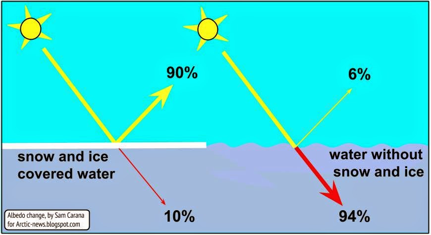
The danger is that warm water will enter the Arctic Ocean and cause the Arctic sea ice to collapse, which could make the Arctic Ocean absorb even more heat. This could unleash huge methane eruptions from the Arctic Ocean's seafloor, in turn driving temperatures up even higher and causing more extreme weather events, wildfires, etc.

The situation is dire and calls for comprehensive and effective action, as discussed at the Climate Plan


For the oceans on the Northern Hemisphere, the June 2015 sea surface temperature was at a record high 0.87°C (1.57°F)...
Posted by Sam Carana on Tuesday, July 21, 2015

Senin, 25 Mei 2015

Sleeping Giant in the Arctic


Huge amounts of carbon are contained in sediments, soils and vegetation in the Arctic. Rising temperatures in the Arctic threaten to cause much of this carbon to be released to the atmosphere.

On May 23, 2015, temperatures in Alaska were as high as 91°F (32.78°C), as illustrated by the image below.

[ image credit: US National Weather Service Alaska ]
High temperatures were reached at the city of Eagle, located on the southern bank of the Yukon River, at an elevation of 853 ft (260 m). High temperatures at such a location will cause meltwater, aggravating the situation well beyond the local area.
A bank of permafrost thaws near the Kolyma
River in Siberia. Credit: University of Georgia

Carbon contained in soils will thus become increasingly exposed under the combined impact of rising temperatures and the associated growing amounts of meltwater. The meltwater can additionally cause erosion further downstream, thus making carbon at many locations become more prone to be consumed by microbes and released into the atmosphere in the form of carbon dioxide and methane.

A recent study found that, at a location where the Kolyma river in Siberia carved into the permafrost and exposed the carbon, microbes converted 60% of the carbon into carbon dioxide in two weeks time.

Gary Houser, who recently launched the movie Sleeping Giant in the Arctic, elaborates on the threat of emissions from thawing permafrost:
This immense release would likely feed on itself, raising temperatures that continue melting more and more permafrost in a vicious, frightening, and unstoppable cycle. A tipping point could well be crossed, at which time human intervention is no longer possible. Temperatures across the planet could soar, setting in motion catastrophic levels of drought and food shortage. All life support systems on earth and life forms themselves could be placed under severe stress.

The colossal scale of the danger - and the observation of those factors lining up that could trigger it - demand that humanity exercise the precautionary principle. All political decision-making related to carbon emissions must be based on the understanding that a catastrophic consequence is looming, and the window of time for prevention quickly diminishing.
SLEEPING GIANT IN THE ARCTIC:
Can Thawing Permafrost Cause Runaway Global Heating?
by Gary Houser


Sources: 

US National Weather Service Alaska

University of Georgia

Sleeping Giant in the Arctic


Sleeping Giant in the Arctic http://arctic-news.blogspot.com/2015/05/sleeping-giant-in-the-arctic.html

Posted by Sam Carana on Monday, May 25, 2015

Jumat, 15 Agustus 2014

Heatwave to hit Greenland

A heatwave with temperature anomalies exceeding 36°F (20°C) is expected to hit Greenland between August 16 and 22, 2014, as illustrated by the image on the left and the animation on the right. 

Such heatwaves can be expected to hit the Arctic more frequently and with greater intensity, as temperatures in the Arctic are rising faster than elsewhere on Earth.

Such heatwaves can result in massive melting on Greenland, as persistent heat changes the texture of the snow and ice cover, in turn reducing its reflectivity. This makes that less sunlight is reflected back into space and is instead absorbed. 

The image below illustrates what a difference the presence of sea ice can make.
from: Arctic Warming due to Snow and Ice Demise
As the NSIDC/NOAA graphs below shows, melting on Greenland has been relatively modest this year when compared to the situation in 2012. By July 12, 2012, 97% of the ice sheet surface had thawed, according to this NASA analysis and this NOAA Arctic Report Card.


Melting on Greenland directly affects sea level rise, and melting on Greenland is accelerating due to a number of factors.

Projections of melting on Greenland have long been based on a warming atmosphere only, ignoring the warmer waters that lubricate glaciers and that warm Greenland's bedrock canyons that sit well below sea level.

Furthermore, there are growing quantities of black carbon deposits as a result of burning of fossil fuel and biomass. High temperatures have recently caused ferocious wildfires in Canada that have in turn caused a lot of black carbon to go up high into the atmosphere.

And of course, the atmosphere over the Arctic is warming up much faster than most models had projected. This in turn causes triggers further feebacks, including more extreme weather events such as heatwaves and rain storms that can be expected to hit Greenland with ever more frequency and ferocity. Further feedbacks include methane eruptions from the heights of Greenland, as discussed at the Arctic Feedbacks Page.

When also taking into account the accelerating impact of such factors on melting in Greenland, sea levels could rise much faster than anticipated, as illustrated by the image below.

from: more than 2.5m sea level rise by 2040? 

Note that sea level rise is only one of the many dangers of global warming, as discussed in the 2007 post Ten Dangers of Global Warming.

The image on the right shows a temperature forecast for August 16, 2014, with parts of Greenland changing in color from blue into green, i.e. above the melting point for snow and ice.

Such high temperatures are now hitting locations close to the North Pole ever more frequently, due to the many feedbacks that are accelerating warming in the Arctic, as discussed at this Feedbacks page.

One of the most dangerous feedbacks is a sudden eruption of huge quantities of methane from the seafloor of the Arctic Ocean, as discussed in a recent post.

The impact of such feedbacks can be accumulative and interactive, resulting in self-reinforcing feedbacks loops that can escalate into runaway warming.

Below is another forecast by ClimateReanalyzer for August 16, 2014, showing the remarkable ‘greening’ of Greenland, as well as the very high temperatures reaching the higher latitudes of North America.


Also see the very high sea surface temperatures around Greenland on the image below, created with ClimateReanalyzer.

Sea surface temperature anomalies on August 15, 2014. 
In conclusion, the situation is dire and calls for comprehensive and effective action, as discussed at the Climate Plan blog


Sabtu, 15 Februari 2014

Extreme weather strikes around the globe - update

As the weather gets more extreme, disaster strikes around the globe. The Guardian reports three people killed as storms continue to batter southern UK. The Vancouver Sun reports that a U.S. Northeast snowstorm kills 25. And the Sacramento Bee reports Six dead and 1,000 injured in fresh Japan snow storm.

What is the story behind these extreme weather events? The image below tells the story. The Arctic has been much warmer than it used to be, due to numerous feedbacks that accelerate warming in the Arctic. This reduces the temperature differential between the Arctic and lower latitudes, which changes the Jet Stream and Polar Vortex, in turn making the weather at many places ever more extreme.

 earlier forecasts by cci-reanalyzer.org
Above image illustrates the situation, showing an Arctic Ocean that is warmer than the higher latitudes of the Asian and North American continents.

Arctic sea ice has meanwhile reached record lows, as illustrated by the image below.


The situation can be expected to get even worse. The image below shows sea ice extent, as measured by the NSIDC, which is one day ahead compared to above image.


Below, two regular contributors to the Arctic-news blog comment on the situation.


    Paul Beckwith:

Paul Beckwith with sign (arrows highlighted by Sam Carana, from earlier post)
In the video below, Paul Beckwith discusses the above sign and the situation in general.


Dr. Malcolm Light, Earth Scientist, comments:


The volume of water transported by Gulf Stream off the east coast of the United States has increased by three times since the 1940s due to a massive increase in wind drag. This increase in the south westerly wind drag is a result of the continuously increasing pressure difference set up between the continental air mass over North America, heated by fossil - fuel generated carbon dioxide, and the marine air of the Atlantic.

The increased energy entering the Gulf Stream as heat and its associated winds and storm systems are what are now pummeling Great Britain and Europe. This heat is also transported further north by branches of the Gulf Stream into the Arctic Ocean, where it is destabilizing the subsea methane hydrates, releasing increasing volumes of methane into the Arctic atmosphere and causing temperature anomalies this last winter of more than 20 degrees Celsius.

As a consequence of the extremely high Arctic temperatures and pressures, the normal freezing Arctic air has been displaced into Canada and the United States, causing catastrophic blizzards that have never been seen before. When the floating Arctic ice cap melts towards the end of next year, the Arctic Ocean will then become more aggressively heated by the sun and the northern offshoots of the Gulf Stream.

Under these circumstances, the cold Arctic air will be confined over the Greenland ice cap and the Arctic atmosphere will rotate anticlockwise around Greenland, transferring the fast-increasing amounts of its atmospheric methane to Canada and the United States and causing a further increase in the energy of the Gulf Stream.

Therefore the United Kingdom and Europe must brace themselves for even more catastrophic weather systems, widespread flooding and massive wind damage from the start of the last quarter of next year.


Below is a comparison of methane readings for the week from February 9 to 16, 2014, compared to the same period in 2013.


The comparison shows that there is a lot of methane over the Arctic Ocean that wasn't there last year. Furthermore, high methane readings show up where currents move the sea ice out of the Arctic Ocean, in areas such as Baffin Bay. This indicates that methane that is released from the seafloor of the Arctic Ocean appears to be moving underneath the ice and entering the atmopshere where the sea ice is fractured or thin enough to allow the methane to pass through.

Also note that more orange areas show up on the southern hemisphere in 2014, indicating that more methane from the northern hemisphere is now spreading south beyond the equator. This in addition to indications that more methane is rising and building up at higher altitudes, as discussed in an earlier post.

As said before, the situation calls for comprehensive and effective action, as discussed at the Climate Plan blog.


Senin, 10 Februari 2014

Extreme weather strikes around the globe

  Editorial note: this post has meanwhile been updated as
Extreme weather strikes around the globe update.


As the weather gets more extreme, disaster strikes around the globe.

Here's a snapsnot from today's news. In London, the BBC reports, flooded homes along the River Thames are being evacuated and thousands more are at risk. In Japan, reports Reuters, eleven people died, more than a thousand were injured and tens of thousands lost power when the worst snowstorm in decades hit Tokyo and areas around the Japanese capital before heading north to blanket the tsunami-hit Pacific coast. Many countries in the Middle East were hit by snow. The BBC reports that heavy snow in northern Iran has left around 480,000 homes without power and some towns and villages cut off.

What is causing these extreme weather events? The image below tells the story. While at times it has been cold at many places around the world, when averaged over the past 30 days, temperatures around the globe have actually been several degrees higher than they used to be. The Arctic has been hit hardest, with anomalies as high as 21°C over this 30 day period. This affects the Jet Stream and Polar Vortex, which in turn is making the weather ever more extreme.


The situation is further illustrated by the cci-reanalyzer.org forecasts below.


And while the sea ice didn't look too bad at the start of the year, growth has meanwhile stopped, as illustrated by the image below.


Added below are two videos by Paul Beckwith, further discussing the situation.


Editor's note: Reanalysis of temperature anomaly Jan 12 - Feb 10, 2014.
Meanwhile, I've added another image (above), created with NOAA's reanalysis, which compares temperatures to a larger dataset, and the colors look a lot different, so NOAA may indeed have mixed the colors up somewhat in the initial image, as Albert suggested at the Facebook discussion (click on image below).

Anyway, the point made in the post remains, i.e. that as global warming continues, warming in the Arctic accelerates more rapidly than at lower latitudes, which weakens the polar vortex and jet stream in a self-reinforcing feedback that causes the Arctic to warm up even further compared with lower latitudes.

As said, the situation calls for comprehensive and effective action, as discussed at the Climate Plan blog.