This is default featured slide 1 title

Go to Blogger edit html and find these sentences.Now replace these sentences with your own descriptions.This theme is Bloggerized by Lasantha Bandara - Premiumbloggertemplates.com.

This is default featured slide 2 title

Go to Blogger edit html and find these sentences.Now replace these sentences with your own descriptions.This theme is Bloggerized by Lasantha Bandara - Premiumbloggertemplates.com.

This is default featured slide 3 title

Go to Blogger edit html and find these sentences.Now replace these sentences with your own descriptions.This theme is Bloggerized by Lasantha Bandara - Premiumbloggertemplates.com.

This is default featured slide 4 title

Go to Blogger edit html and find these sentences.Now replace these sentences with your own descriptions.This theme is Bloggerized by Lasantha Bandara - Premiumbloggertemplates.com.

This is default featured slide 5 title

Go to Blogger edit html and find these sentences.Now replace these sentences with your own descriptions.This theme is Bloggerized by Lasantha Bandara - Premiumbloggertemplates.com.

Tampilkan postingan dengan label volume. Tampilkan semua postingan

Selasa, 22 September 2015

Arctic Sea Ice 2015 - Update 10

It looks like sea ice has passed its minimum extent for the year 2015, as illustrated by the image below.


There are some differences between the various websites measuring extent, such as to whether the 2015 low was the third or fourth lowest. Japanese measurements show that sea ice extent was 4.26 million square km on September 14, 2015, i.e. lower than the 2011 minimum of 4.27 million square km, as illustrated by the image below.


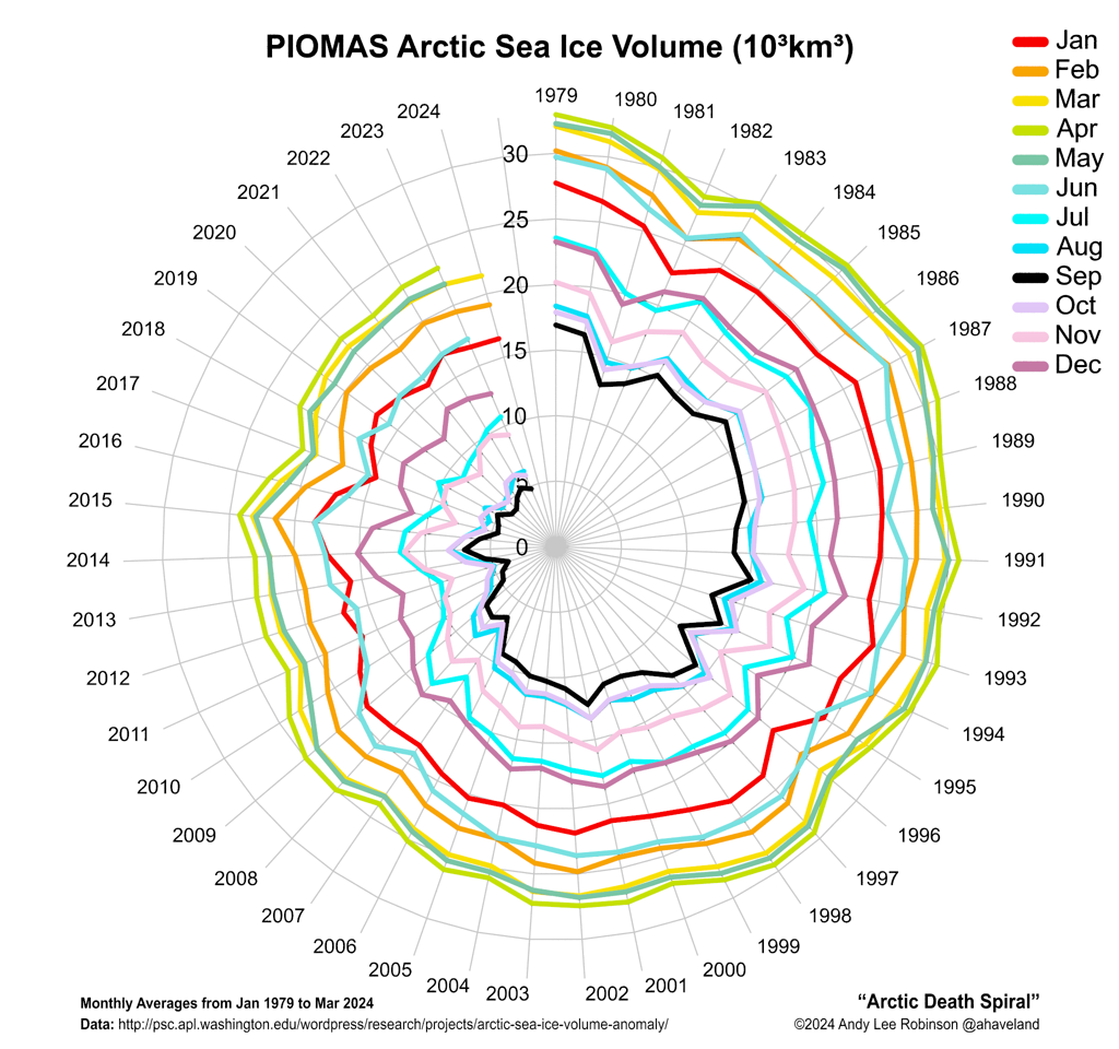
Meanwhile, the Polar Science Center at the University of Washington has announced that Arctic sea ice volume minimum was reached on September 12, 2015, with a total volume of 5,670 cubic km. The image below shows a polynomial trendline based on their annual Arctic sea ice volume minima, including this volume for 2015.


Importantly, the sea ice in many places is now less thick than it was in 2012, as illustrated by the image below, showing sea ice thickness on September 27, 2012 (panel left) and a forecast for September 27, 2015 (panel right).


The reason for the dramatic decrease in thickness of the multi-year sea ice is ocean heat, as illustrated by the image below, showing sea surface temperature anomalies in the Arctic as at September 21, 2015.


The water of the Arctic Ocean is very warm, not only at the surface, but even more so underneath the surface. What has contributed to this situation is described by the image below. From 2012, huge amounts of fresh water have run off Greenland, with the accumulated fresh water now covering a huge part of the North Atlantic.

Since it's fresh water that is now covering a large part of the surface of the North Atlantic, it will not easily sink in the very salty water that was already there. The water in the North Atlantic was very salty due to the high evaporation, which was in turn due to high temperatures and strong winds and currents. As said, fresh water tends to stay on top of more salty water, even though the temperature of the fresh water is low, which makes this water more dense. The result of this stratification is less evaporation in the North Atlantic, and less transfer of ocean heat to the atmosphere, and thus lower air temperatures than would have been the case without this colder surface water.


Meanwhile, global warming continues to heat up the oceans, while less of this ocean heat can now be transferred from the water to the atmosphere in the North Atlantic, since the fresh water is acting like a lid.

The danger is thus that warmer water will be pushed into the Arctic Ocean at lower depth, and that it will reach the seafloor of the Arctic Ocean where huge amounts of methane are contained in sediments. Ice acts like a glue, holding these sediments together and preventing destabilization of methane hydrates. Warmer water reaching these sediments can penetrate them by traveling down cracks and fractures in the sediments, and reach the hydrates.

The big melt in Greenland and the Arctic in general is causing further problems. Isostatic adjustment following melting can contribute to seismic events such as earthquakes, shockwaves and landslides that can destabilize methane hydrates contained in sediments on the Arctic Ocean seafloor.

In the video below, by Nick Breeze, Professor Peter Wadhams discusses the situation.


The situation is dire and calls for comprehensive and effective action as discussed at the Climate Plan.


The water of the Arctic Ocean is very warm, not only at the surface, but even more so underneath the surface. What has...
Posted by Sam Carana on Tuesday, September 22, 2015

Jumat, 18 September 2015

Arctic Sea Ice Collapse Threatens - Update 9

The image below shows that Arctic sea ice had reached a level of 4.45 million square kilometers on September 16, 2015 (end of dark blue line at center of image).


NSIDC has meanwhile called the 2015 minimum, but the first sentence of their post hastens to add that on September 11, Arctic sea ice reached its likely minimum for 2015,  at 4.41 million square kilometers (1.70 million square miles), putting 2015 in the fourth lowest place since satellite records began. Arctic sea ice minimum was lower only in 2012 (dotted line), 2007 (light blue line) and 2011 (orange line). Sea ice extent was 4.413 million square kilometers both on September 9, 2015, as well as on September 10 and 11, 2015.

September 9 would be early for the sea ice to reach its minimum, as a comparison with earlier years on above image illustrates. The dark blue line on above image shows that sea ice extent fell slightly on September 16, compared to the day before, and is now below the 2011 extent (orange line) for this time of the year. Over the next few days, sea ice extent may well fall somewhat further, and reach a level below the 2011 minimum, thus reaching the third lowest minimum extent since record began. This could eventuate due to winds compacting the sea ice.

More importantly, sea ice thickness is still falling, as illustrated by the image below showing the sea ice thickness on September 9 in the left panel and a forecast for thickness on September 24 in the right panel.


The image below compares sea ice thickness between September 24, 2012 (left panel) with that forecast for September 24, 2015 (right panel).


Above image illustrates why the situation in 2015 is even more threatening than it was in 2012. Only the ice that is colored light green, yellow and red is more than 3 meters thick. In 2015, ocean heat has been melting the sea ice from underneath. So, even while the currently lower temperatures of the air may have resulted in a slight increase in extent over the past week, the added ice is very thin. Ocean heat first of all goes into melting the thickest sea ice, i.e. the parts that are meters below the surface. This because the water at surface level is colder than the water underneath the surface. This explains why much of the water surface will remain covered by (very thin) ice as air temperatures are now falling (compared to air temperatures over the past few months).

The image below shows sea surface temperatures as at September 17, 2015.


In conclusion, while the sea ice appears to have survived the 2015 melting season without collapsing, the threat that this will occur in the coming years is ominous. Lack of multi-year sea ice makes that sea ice is in a very vulnerable situation. Total collapse of sea ice is therefore more likely to happen in the coming years. Every time ocean heat will arrive in the Arctic Ocean at its fullest strength in future, this heat will no longer be able to be fully absorbed by the process of melting thick sea ice, so what's left of the sea ice will melt very quickly.

There is a strengthening El Niño, while more open water increases the chance that storms will develop that will push the last remnants of the sea ice out of the Arctic Ocean, as discussed in earlier posts such as this one. Storms can also mix warm surface waters all the way down to the seafloor, as discussed in this earlier post. Cyclones that emerge with greater force due to high sea surface temperatures further increase this danger.

The big danger is that ocean heat will cause methane contained in sediments on the Arctic Ocean seafloor to be released abruptly in large quantities, triggering further methane releases spiraling into runaway warming.

The situation is dire and calls for comprehensive and effective action, as discussed in the Climate Plan.


Below is a text-only version of this post for radio.


Sea ice thickness on September 24, 2012 (left panel) compared to a forecast for September 24, 2015 (right panel). This...
Posted by Sam Carana on Friday, September 18, 2015

Jumat, 31 Juli 2015

Arctic Sea Ice Collapse Threatens - Update 2

The image below shows sea surface temperature anomalies in the Arctic on July 30, 2015.


Due to warm ocean waters and to heatwaves on land that extended over the Arctic Ocean, while warming up rivers ending into the Arctic Ocean, the sea ice has taken a battering over the past few weeks, as illustrated by the images below.


Above image shows the last bit of thick (5 m) sea ice in the Canadian Archipelago, which became dislodged on July 8, 2015. It looks set to be virtually gone by August 7, 2015, according to the 30-day Naval Research Laboratory animation below, and as also discussed in greater detail in a recent post.


The situation at the north-eastern tip of Greenland doesn't look much better, as illustrated by the image below.


The comparison image below also shows the north-eastern tip of Greenland on July 5, 2015 (top), and on July 31, 2015 (bottom). The bottom image shows water in many places, pushing the last pieces of thick ice into the Wandel Sea and Fram Strait .

[ click on images to enlarge ]
Until now, the thicker multi-year sea ice used to survive the melting season, giving the sea ice strength for the next year, by acting as a buffer to absorb heat that would otherwise melt away the thinner ice. Without multi-year sea ice, the Arctic will be in a bad shape in coming years. 

[ click on images to enlarge ]
What caused the dramatic melting of this thick ice? The left panel of above image shows temperatures. On July 29, 2015, temperatures as high as 23.1°C (or 73,7°F) were recorded on the north coast of Victoria Island, in the Canadian Archipelago (green circle where the arrow points at). The satellite image on the right, captured that same day, shows that hardly any ice was left in the waters surrounding the area.


So, will the sea ice collapse this year? Consider the following four points:

Volume - The image on the top right shows sea ice volume as calculated by PIOMAS at the University of Washington. It shows that in June, volume was less than 2015 in only four years, i.e. 2010 through to 2013. The situation has deteriorated much in July 2015, and looks set to deteriorate even further.

Thickness - Volume is calculated by looking at both thickness and extent. Thickness is looking much worse than it did in the years 2012 through to 2014, as illustrated by above image.

In my experience, sea ice thickness hasn't looked this bad for this time of the year since records began, especially when taking the loss of multi-year ice into account, as also illustrated by the full-width above image.


Extent - Sea ice extent on July 31 was only outside the 2 standard deviations (shaded area) in the years 2007, 2011 and 2012, as illustrated by the image mid right. The dark blue line marks the 2015 extent, with the dot indicating extent on July 31, 2015.

Area - Similarly, Arctic sea ice area is illustrated by the image on the right. For a description of the difference between extent and area, view this NSIDC FAQ page. The bottom right image marks Arctic sea ice area as on July 30, 2015. The yellow marker indicates the situation for the year 2015 on this date. The only years with less sea ice area at this time of the year were 2007, 2011 and 2012.

Also consider that 2015 features very high sea surface temperatures and an El Niño that is still gaining in strength. Thick sea ice appears to be shattered, as illustrated by the satellite images. In conclusion, sea ice looks set to take a further battering over the next few weeks and could end
up at a record low thickness, extent, area and volume around half September 2015.

With that in mind, let's take a look at the image below.


Above image shows a trendline (shaded area) based on satellite data from 1979-2014, with annual minimum volume figures calculated by PIOMAS. The shaded area points at a total disappearance of the sea ice as early as September 2018. The width of the shaded area reflects natural variability, but natural variability could be wider than that, as illustrated by the fact that minimum volume in the years 2007, 2010, 2011 and 2012 was lower than the shaded area. In other words, disappearance of the sea ice could occur even earlier than September 2018 and if things get really bad, collapse could even occur as early as September this year.

The situation is dire and calls for comprehensive and effective action, as discussed at the Climate Plan.


Will the sea ice collapse this year? Firstly, consider that sea ice volume now hasn't been this bad for any day in July...
Posted by Sam Carana on Friday, July 31, 2015

Minggu, 19 Juli 2015

Arctic Sea Ice Collapse Threatens - Update 1

The image below compares the Arctic sea ice thickness (in m) on July 15, for the years from 2012 (left panel) to 2015 (right panel), using Naval Research Laboratory images.

Click on image to enlarge
The image below compares the Arctic sea ice concentration (in %) on July 18, for the years from 2012 (left panel) to 2015 (right panel), using Naval Research Laboratory images.


Above images show the dramatic decline of the sea ice in 2015, both in thickness and in concentration.

In terms of thickness, sea ice has been reduced by more than one meter in many places, such as north of Greenland and the Canadian Archipelago, all in the time span of just one month.

The dramatic fall in sea ice concentration also becomes apparent when comparing recent sea ice concentration (July 18, 2015, above right) with sea ice concentration back in May 2015 (image right, May 1, 2015).

This dramatic decline of the sea ice in 2015 is the result of a combination of factors, including:

  1. High levels of greenhouse gases over the Arctic Ocean, as illustrated by the image below, showing that on July 17, 2015 (pm), levels as high as 2512 parts per billion were recorded at 6,041 m (19,820 ft) altitude, while mean methane levels were 1830 parts per billion at this altitude.
  2. High levels of ocean heat, as illustrated by the image below showing high sea surface temperatures off the east coast of North America; much of this ocean heat will be carried by the Gulf Stream into the Arctic Ocean over the next few months.
  3. High air temperatures over North America and Siberia extending over the Arctic Ocean, as illustrated by the image below showing a temperature of 23.1°C (73.7°F), recorded on July 19, 2015, at Banks Island, in the Canadian Archipelago (green circle).
  4. Wildfires triggered by these heatwaves resulting in darkening compounds settling on snow and ice, as illustrated by the image below showing smoke covering a wide area on July 19, 2015, from the east Siberia over North America to the southern tip of Greenland.
  5. Very warm river water running into the Arctic Ocean, as illustrated by the image below, showing sea surface temperatures as high as 19°C (66.2°F) off the coast of Alaska on July 12-15, 2015.
The image below shows the already very high sea surface temperature anomalies as at July 18, 2015.

The Climate Reanalyzer image below shows the high sea surface temperature anomalies in the Pacific Ocean, and where water enter the Arctic Ocean through the Bering Strait, on July 19, 2015.


With still two months of melting to go before the sea ice can be expected to reach its minimum for 2015, the threat of sea ice collapse is ominous. The Arctic-News Blog has been warning for years about the growing chance of a collapse of the sea ice, in which case huge amounts of sunlight that previously were reflected back into space, as well as heat that previously went into melting the ice, will then instead have to be absorbed by the water, resulting in a dramatic rise of sea surface temperatures.

More open water will then come with an increased chance of storms that can cause high sea surface temperatures to be mixed down all the way to seafloor of the Arctic Ocean, which in many cases is less than 50 m (164 ft) deep. This is the case for the East Siberian Arctic Shelf, where experts estimate that huge amounts of methane are contained in subsea sediments. Already now, sea surface temperatures as high as 10°C (~50°F) are recorded there, as illustrated by the image below.


Massive amounts of ocean heat will be carried by the Gulf Stream into the Arctic Ocean over the next few months. The combined result of high sea surface temperatures being mixed down to the seafloor and the ocean heat entering the Arctic Ocean from the Atlantic and Pacific Oceans can be expected to result in dramatic methane eruptions from the Arctic Ocean seafloor by October 2015.

The situation is dire and calls for comprehensive and effective action, as discussed at the Climate Plan.


Arctic sea ice thickness on July 15, compared over the years 2012 through to 2015. Already virtually all the thick sea...

Posted by Sam Carana on Thursday, July 16, 2015

Senin, 09 Juni 2014

Arctic Sea Ice Steep Decline Continues


Steep decline of the Arctic sea ice continues. The yellow line on the image below follows 2014 sea ice area up to June 5 and shows that sea ice area now is close to a record low for the time of the year.

[ click on image to enlarge ]
The Naval Research Laboratory image below compares sea ice concentration on May 14, 2014 (left) with the sea ice concentration forecast for June 15, 2014 (run on June 7, 2014, on the right).


Above image shows falling sea ice concentration, with low sea ice concentration extending to the center of the Arctic Ocean.

Low sea ice concentration at the center of the Arctic Ocean is an ominous sign; at last year's minimum, very little sea ice was left close to the North Pole, as discussed in an earlier post.

On the right is an image of the University of Bremen showing sea ice concentration on June 8, 2014 (click on the images to enlarge them).

Arctic sea ice already is very thin, as discussed in recent posts. The image below shows that the sea ice volume trend down to zero was confirmed for the months April and May 2014.

[ image by Andy Lee Robinson based on PIOMAS data, click on image to enlarge ]
The lowest sea ice volume for 2014 is expected to be reached in September, and - given the shape the ice is in now - will likely be one of the lowest minima on record. In fact, there is a chance that there will be no ice left whatsoever later this year. As illustrated by the image by Wipneus below, an exponential curve based on annual minima from 1979 points at zero ice volume end 2016, with the lower limit of the 95% confidence interval pointing at zero ice end of 2014.
As the sea ice disappears, a lot more heat will be absorbed by the Arctic Ocean. Sea ice reflects 50% to 70% of the incoming energy, describes NSIDC.org, but thick sea ice covered with snow reflects as much as 90% of the incoming solar radiation. Melting of snow creates melt ponds on the ice and because shallow melt ponds have an albedo of approximately 0.2 to 0.4, the surface albedo drops to about 0.75. As melt ponds grow and deepen, the surface albedo can drop to 0.15. The ocean reflects only 6% of the incoming solar radiation and absorbs the rest. Snow and ice decline comes with a further feedback in that all the energy that during the melt went into transforming ice into water will - in the absence of ice - now be absorbed by the ocean as well.

Accelerated Warming in the Arctic

[ from the post Near-Term Human Extinction ]
Such feedbacks are causing warming to accelerate in the Arctic Ocean, as depicted in above image and described in the earlier post Feedbacks in the Arctic. Much of the Arctic Ocean is very shallow and the seafloor is thus vulnerable to warming. The Gulf Stream can be expected to keep carrying warmer water into the Arctic Ocean, so the situation is dire, while extreme weather events such as heatwaves and cyclones can make the situation even worse.

The NOAA image below shows huge sea surface temperature anomalies all over the Northern Hemisphere on June 8, 2014.

[ click on image to enlarge ]
Large areas with sea surface temperature anomalies up to 8°C and higher show up in and around the Arctic Ocean, as further illustrated by the image below.

[ click on image to enlarge ]
The image below shows high sea surface temperature anomalies from February 21, 2014, up to June 9, 2014, on the Northern Hemisphere (red bars), next to global average anomalies (orange/shaded bars).


The global sea surface temperature anomaly is worrying (a 1.25°C anomaly was reached on May 22, 2014). See the NOAA website to compare this with earlier months. Note that on specific spots the anomaly is much higher, as illustrated by the images further above.

Warm surface waters in the Arctic sea ice spell bad news, given that the sea ice is already at or close to record lows, in terms of area and volume.

And as ocean heat threatens to melt the sea ice from beneath, the sun is now strongly warming up the ice from above. Insolation in the Arctic is at its highest at this time of year, as Earth reaches its maximum axial tilt toward the sun of 23° 26'. In fact, insolation during the months June and July is higher in the Arctic than anywhere else on Earth, as discussed at this earlier post.

The diminishing temperature difference between the equator and the North Pole reduces the speed at which the Jet Stream circumnavigates Earth and it makes the Jet Stream become wavier, increasing opportunities for cold air to escape from the Arctic and for warm air to move in. More extreme weather increases the chance of intense and prolonged heatwaves and fierce cyclones, storms and winds to hit the Arctic Ocean.

Making things even worsen, there is the prospect of an El Niño event, projected to occur later this year. According to NOAA (June 5, 2014), the chance of El Niño is 70% during the Northern Hemisphere summer and reaches 80% during the fall and winter. El Niño odds are even higher than this, according to this post at the Wunderground blog.


Methane

Temperature rises of the water close to the seafloor of the Arctic Ocean are very dangerous, as heat can penetrate sediments and cause hydrate destabilization. Huge amounts of methane are held in sediments at the seafloor, in the form of free gas and hydrates. In shallow waters, methane released from the seafloor can more easily enter the atmosphere without getting broken down by microbes in the water.

Methane levels are already very high. On June 6, 2014, mean global methane reached levels as high as 1809 ppb, with peaks as high as 2516 ppb.

Methane release from the seafloor of the Arctic Ocean will warm up the Arctic even further, triggering even more methane releases, heatwaves, wildfires and further feedbacks, in a spiral of runaway warming, threatening to cause starvation, destruction and extintion at massive scale across the globe.


Earthquakes

Earthquakes are a further worry. A huge amount of melting takes place in Greenland, as described in the post Ten Cubic Kilometers of Ice Lost From Jakobshavn Glacier in Less than One Month. As the ice disappears, a large weight is lefted from Greenland, causing the Earth's crust there to be lifted in a phenomenon referred to as isostatic rebound. This can cause earthquakes to occur on the seafloor of the waters around Greenland, as illustrated by the image below.

[ click on image to enlarge ]

As the image below shows, the faultline alongside Greenland crosses the Arctic Ocean and extends into the Laptev Sea and Siberia, an area recently hit by two large earthquakes.

[ click on image to enlarge ]
Earthquakes in this region are very worrying. Earthquakes can trigger further earthquakes, especially at locations closeby on the same faultline. Earthquakes and subsequent shockwaves and landslides can further contribute to destabilization of methane hydrates contained in sediments under the seafloor of the Arctic Ocean.

In conclusion, the situation is dire and calls for comprehensive and effective action, as discussed at the climate plan blog.


Related

- M4.4 Earthquake hits Arctic Ocean north of Greenland
http://arctic-news.blogspot.com/2014/04/m45-earthquake-hits-arctic-ocean.html

- M4.5 Earthquake hits Arctic Ocean
http://arctic-news.blogspot.com/2014/04/m45-earthquake-hits-arctic-ocean.html

- Earthquakes in the Arctic Ocean
http://arctic-news.blogspot.com/2014/04/earthquakes-in-the-arctic-ocean.html

- Methane, Faults and Sea Ice
http://arctic-news.blogspot.com/2013/11/methane-faults-and-sea-ice.html

- Norwegian Sea hit by 4.6M Earthquake
http://arctic-news.blogspot.com/2013/11/norwegian-sea-hit-by-46m-earthquake.html

- Greenland Sea hit by M5.3 Earthquake
http://arctic-news.blogspot.com/2013/10/greenland-sea-hit-by-m53-earthquake.html

- Earthquake hits waters off Japan
http://arctic-news.blogspot.com/2013/10/earthquake-hits-waters-off-japan.html

- Earthquake hits Laptev Sea
http://arctic-news.blogspot.com/2013/09/earthquake-hits-laptev-sea.html

- Methane Release caused by Earthquakes
http://arctic-news.blogspot.com/2013/09/methane-release-caused-by-earthquakes.html

- Earthquake M6.7 hits Sea of Okhotsk
http://methane-hydrates.blogspot.com/2013/10/earthquake-m67-hits-sea-of-okhotsk.html

- Sea of Okhotsk
http://methane-hydrates.blogspot.com/2013/06/sea-of-okhotsk.html

- Seismic activity
http://arctic-news.blogspot.com/p/seismic-activity.html

- Climate Plan
http://climateplan.blogspot.com

Jumat, 09 Mei 2014

Outlook for sea ice remains bleak


In April 2014, Arctic sea ice reached its annual maximum volume. It was the second lowest on record, according to calculations by the Pan-Arctic Ice Ocean Modeling and Assimilation System (PIOMAS) at the Polar Science Center. The ice volume in March 2014 also was the second lowest on record, as discussed in an earlier post. The fall in volume over the years is illustrated in the graph below, by Wipneus.
Another way of depicting the continuing fall in sea ice volume is the Arctic Death Spiral below, by Andy Lee Robinson.

The graph below, from the Danish Metereological Institute, shows mean temperatures that have been much higher than they used to be at higher latitudes. Mean 2 m temperatures for the region north of the 80th northern parallel as a function of the day of year are shown (red line), against the 1958 - 2002 mean (green line).


High levels of methane over the Arctic will have contributed to these high temperatures. Furthermore, the Jet Stream is changing as the difference in temperature between the Arctic and the equator decreases, causing more extreme weather events such as heatwaves and storms that could speed up the demise of snow and ice cover in the Arctic.

The graph below, by the Japan Aerospace Exploration Agency, shows that Arctic sea ice extent was 12,469,546 km² on May 8, 2014.

In addition, an El Niño event could cause even more ferocious heatwaves and storms to hit the Arctic. The image below, from IRI at Columbia University, shows that the chance of an El Niño event developing in the course of 2014 is close to 80%.


The outlook for the sea ice remains bleak and the possibility that a total collapse could occur in September calls for comprehensive and effective action, as discussed at the climate plan blog.